Portland Maps
Portland, like most American cities, is easy to explore by car – it’s not overly challenging to navigate, and save for a few more densely-packed neighborhoods, finding street parking is relatively easy. Anyone staying downtown or fairly close to downtown in the city center (on either side of the river) can actually get around just fine without a car, relying on the city’s excellent public transportation. No matter how you choose to transport yourself around the city, however, having a good map of Portland is helpful.
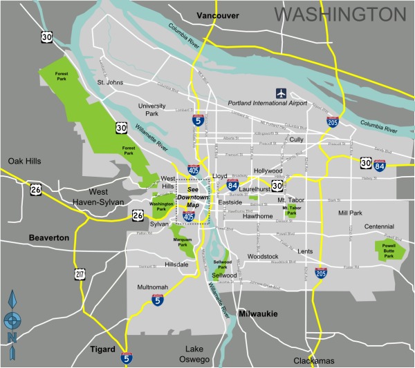
Here’s a map of Portland, including its proximity to the nearby suburbs that make up the greater Portland Metro area:

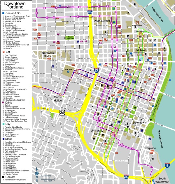
Here’s a map of downtown Portland, where you can see the city’s grid system clearly:

Explore Portland’s neighborhoods in more detail:
While these maps will give you an idea of where things are and how the city is laid out, you’ll need something more detailed that you can hold in your hands when it comes time to actually find your way around. Here are some good paper maps you can get to navigate around Portland (some of them include the surrounding area, some do not – make sure you know what parts of the Metro area you want to visit so you know whether the map you’re looking at covers that area).
- Streetwise Laminated City Center Street Map of Portland, Oregon (with Max Light Rail map) – on Amazon for $6.95
- Rand McNally Streets of Portland (including Fairview, Gresham, Johnson City, Lake Oswego, Milwaukie, Tigard, Troutdale) – on Amazon for $5.99
- The Thomas Guide Portland Street Guide – on Amazon for $22.45
- Rand McNally Oregon State Map – on Amazon for $5.99
- Benchmark Oregon Road & Recreation Atlas – on Amazon for $20.17
You may already know the fondness Portlanders have for their iPhones, so if you’re looking for Portland maps that are iPhone apps, you’re in luck. Here are a few you can choose from:
- Portland Map Offline ($2.99) on iTunes App Store
- Portland, OR Map in less than 20MB ($1.99) on iTunes App Store
- Nav4D Oregon ($18.99) on iTunes App Store
- Portland Insider ($2.99) on iTunes App Store
- VectorMaps Oregon ($0.99) on iTunes App Store
Don’t miss our list of the 12 must-have Portland iPhone apps – which include a few map-related apps. There are also some PDF maps of the city – including certain neighborhoods, day trip destinations, and public transportation lines – on the Travel Portland website that you can download for free.
map images by PerryPlanet, PerryPlanet